The field of geography is also based on different types of maps. They can be used to study the features of our planet. Some maps are top-rated and are recognized even by children or schoolchildren. Some maps are used only by professionals in specialized fields of work.
One type is thematic maps, which show specific data, such as the average rainfall distribution in a particular area. There are also topographic maps, political maps, physical maps, and the list goes on.
Table of Contents:
Maps describing the surface of the earth
To know precisely what topographic maps describe, it is first of all necessary to understand the concept of topography. It is a geographical concept related to the description and study of the surface features of our planet. It describes physical geographical features such as slope, elevation, and gradient.
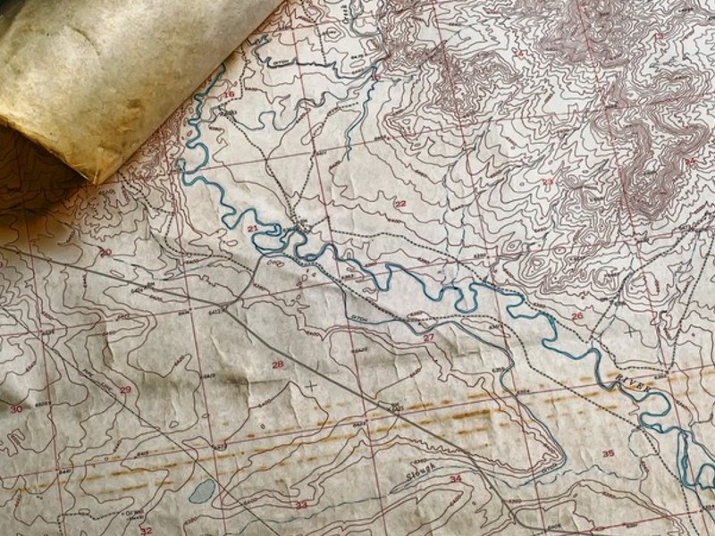
Topographic maps detail ground relief (landforms and terrain), lakes and rivers, forests, administrative areas, populated areas, transportation routes and facilities (including roads and railways), and other features.
Geographical research in topography took off in the 19th century. Most national geographic surveys only described the altitudes of particular points on their maps. Nevertheless, the first topographic map with isohypses was published in France as early as 1784.
A topographic map most closely resembles a physical map
There are also topographic maps or charts. These most closely resemble physical maps. They show the various physical features of the landscape chosen. Unlike physical
Introduction to Topographic Maps – How To Read Them
Contour lines on a topographic map are usually spaced at regular intervals. This allows them to show elevation changes. Each line thus represents a 100-metre change in altitude. However, when the lines are very close, the terrain is steeper.
What are climate maps?
Climate maps show information about the climate in a particular area.
For example, they can show the specific climate zones of an area based on the amount of snowfall and temperature.
These types of maps usually use colors to show different climate zones.
Road maps
Road maps are a prevalent type of map. They show major and minor highways and roads.
The latter mainly depends on the detail. They can also show airports, locations, and places of interest, such as monuments, parks, and campsites. Major motorways are usually marked with red lines on such maps and more prominent lines than other types of roads. Minor roads are marked in a lighter and narrower color.